≡ Menu

Long Land Water

“Long Land Water” of the Indians becomes the New Jersey of the British

We shall probably never know the name of the first European to sight the New Jersey shore line and Long Beach. Most historians today credit Henry Hudson with the distinction of having been the first to land.

As will be remembered, he was an Englishman employed by the Dutch East Indies Company. On April 4, 1609, he sailed in search of a Northwest Passage to India. His single ship, the “Half Moon,” was a two-masted vessel of about eighty tons, manned by a crew of twenty.

Henry Hudson's ship the Half Moon

Henry Hudson’s ship the Half Moon

Hudson sighted Newfoundland, then coasted down the shore, landing near the present Portland, Maine. He then rounded Cape Cod and sailed southward as far as the Virginia Capes. There he turned about and entered the Delaware Bay on August 28, 1609. Unable to locate deep water to his liking, and fearing the shoals, he again put to sea and sailed up the New Jersey coast.

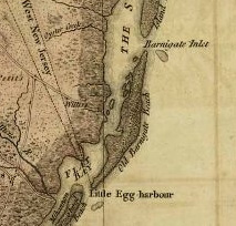
It is said he anchored off Barnegat Inlet for the night of September 2, 1609. The next day he dropped anchor at Sandy Hook in four and one-half fathoms of water and twelve hundred feet from the beach.

A landing was made on Friday, September 4, 1609. Accounts of this event differ. Some claim that Hudson first sent a small boat manned by a few of his crew to ascertain whether the Indians were friendly. Others contend that Hudson led the landing party and was the first European to step ashore on the soil of New Jersey.

Hudson remained at sandy Hook for eight days during which the first hostile act on the part of the Indians occurred. On Sunday, September 6, 1609, one of the sailors, John Coleman or Colman, a member of a small boat crew, was shot through the neck by an arrow and died. Two other members of the boat party were wounded.

Again accounts differ. Some contend that the small boat was close to shore and that the attacking Indians were hidden in the foliage. Others hold that Hudson was in charge and that his boat was pursued by several canoes carrying a war party of Indians.

In any event John Coleman was killed and buried at the foot of one of the gnarled cedar trees that lined the shores of Sandy Hook for so many years. This was most probably the first encounter between Europeans and American Indians within the limits of the present State of New Jersey.

But many Europeans must have sighted the New Jersey coast line and Long Beach before Henry Hudson. And it is even possible that some of these mariners were shipwrecked on the treacherous shoals.

John Cabot, a Venetian, with his son Sebastian, sailed from Bristol, England in 1497 in the service of Henry VII. From Newfoundland the Cabots sailed down the eastern coast of North America as far as cape Hatteras and possibly as far as Florida. This fact seems to have been ignored by most historians. The Cabots must have sailed along and sighted the New Jersey Coast and Long Beach.

A Florentine, Giovanni Verranzo, commanding a squadron of three vessels for King Francis I of France, sailed along the Atlantic coast of North America. It is known that he sailed into New York Bay in 1523. In the same year a Portuguese, Estevan Gomez, sailing for Emperor Charles V of Portugal, is believed to have done some exploring along the shores of both the Delaware and Hudson Rivers.

It is not only possible but quite probable that the intrepid Norse navigators sailed along this coast as early as 1000 A. D. These men may have landed on the New Jersey shores. Some day we will probably know whether these seamen were the first to discover New Jersey, some hundreds of years before the present accepted dates.

Nova Caesarea – New Jersey

What is now the State of New Jersey had many names in the past. The Indians called it “Skaabee” or “Scheyichbi,” generally translated as “Long Land Water.” The Swedes knew it as “Nye Svierge” or “New Sweden, along with their settlements on the west banks of the Delaware. The Dutch called it “Nova Belgia,” and when included with New York it became “New Netherlands.”

The flags of three monarchic governments flew over what is now New Jersey. That of the Sweden until 1654, when the Dutch took control for ten years. The British then conquered the Dutch and held sway for more than a century.

The British, under Colonel Richard Nicolls, seized “New Netherlands” from the Dutch on August 27, 1664 (O.S.) in the name of the Duke of York. Colonel Nicolls called the land west of the Hudson River, including New Jersey, ‘Albania.”

On June 23 and 24, 1664 (O. S.), James, Duke of York, had granted the land between the Hudson and Delaware Rivers to two royal favorites: John, Lord Berkeley, privy councilor and Baron of Stratton: and Sir George Carteret, who had been treasurer of the Royal Navy.

The land was to be known as “Nova Caesarea” or “New Jersey,” as a compliment to Carteret who had successfully defended the Isle of Jersey in the Puritan Civil War of 1643.

After the land division was agreed upon, Carteret became proprietor of East New Jersey and Lord Berkeley became proprietor of West New Jersey.

Colonel Nicolls, while administering the affairs of New York, had granted licenses to several settlers from the New Haven Colony, in Connecticut, to purchase large tracts of land in northern New Jersey from the Indians.

The settlers from New England came down, took up their lands and proceeded to make their own laws to govern themselves. Finally, in a letter dated November 25, l672, the Duke of York annulled these grants in order to solidify the Colony. However, many North New Jersey settlers who held their lands under grants from colonel Nicolls refused to pay quit-rents to the Proprietors.

After many conflicts with the settlers, the proprietors, in 1702, surrendered the governing powers back to the crown and New Jersey became a Royal colony under the administration of Lord Cornbury, Royal Governor of New York.

The Colony of New Jersey continued to be governed by the Royal Governor of New York until 1738, when, in order to appease a rising resentment, particularly among the farmers, New Jersey was given its own governor.

Lord Berkeley disposed of his portion of New Jersey in 1675. After much discussion, George Keith, Surveyor-General of East Jersey, in 1687, was ordered by the Proprietors to run a dividing line between East and West New Jersey.

The Gateway to Long Beach – 3

The Third Port of Entry

Tuckerton has the distinction of having been the third Port of Entry in the United States. After the formation of this Nation, Philadelphia, the then largest city, became the first Port of Entry. This was followed by New York and then by Tuckerton. The commission is dated March 21 1791, and is signed by George Washington as President and Thomas Jefferson as Secretary of State.

Ebenezer Tucker was the first Collector of the Port of Tuckerton and since his time the Collector’s Office has always been in the home of the man holding the appointment. Collectors following Tucker were Charles Bartlett, John T. Burtan, Samuel Bartlett, George W. Mathis, George Crammer, James E. Otis and William Allen, Jr. Several of these men held office when more than a hundred schooners registered Tuck­erton as their home port.

Tuckerton Schooners and Ebenezer Tucker

Great forests of fine hardwood trees which once surrounded Tuckerton made it an important ship building center, thriving under the enterprise of early Quaker settlers. Tuckerton built schooners were well thought of by salt water sailors and many were engaged in a substantial coastal trade.

Bartlett’s Coaling Dock was located on the west bank of Tuckerton Creek about midway to the Bay, and a century ago was a place of considerable importance. Here teams brought their loads of cord wood and large wagons brought their bushels of charcoal. Two masted schooners carried this fuel to Philadelphia and Boston to heat homes. All that now remains of this once busy dock are a few rotting timbers and short piling stumps in the water.

According to the records of the Post Office Department a post office was established at Tuckerton on August 18, 1797. The early post­masters and their dates of appointment were: Reuben Tucker, August 18, 1797; William Watson, February 25, 1801; David Stoute, July 1, 1805; and Ebenezer Tucker, December 28, 1805. He served until May 8, 1840.

Ebenezer Tucker performed many services for his community, state and nation. He served in the Continental Army during the Revolution and was elected to Congress in 1825-1829, serving in the Nineteenth and Twentieth Congresses. He was appointed a judge of the Common Pleas Court and Orphan’s Court and was a justice of the court of Quarter Sessions.

Around 1800 he built and established “Union Inn” at Tuckerton, a portion of which is incorporated in the present “Carlton House.” He owned several schooners, some of which were engaged in the West Indies trade, loading lumber at Tuckerton and returning with sugar and molasses. In addition to this he was one of the original directors of “The Burlington County Bank,” organized in 1837 at Medford, Burling­ton County.

Ebenezer Tucker died September 5, 1845, and is buried in the Meth­odist Cemetery at Tuckerton, his grave being marked by the dominat­ing obelisk of the burying ground.

Edward Andrews and Willow Landing

The buildings at Main and Water Streets, Tuckerton, are supported by portions of the foundations of the original Edward Andrews glist mill. Tuckerton is like that – the new is built upon the old and looks to the old for support and finds it.

Edward Andrews, the reputed founder of what is now Tuckerton, was born on the 16th of the First Month, 1677. When he grew up he acquired some ftve hundred acres on the east side of Tuckerton Lake. He married Sarah Ong, a daughter of Sarah Ong, Sr., believed to have been a widow at the time of her daughter’s marriage. The wedding took place at the home of Thomas Revell in Burlington on February 8, 1694.

Edward Andrews tired of taking his grain to Burlington to have it ground and in about 1704 erected a grist mill at the beaver dam, where today’s shore road curyes around the south end of Tuckerton Lake. This was the first grist mill in the area.

In 1708 Edward Andrews conveyed two acres of land on the east side of the Lake, well back from the road, to the Trustees of the local Quaker Meeting. A one story meeting house was immediately built on this land, John Crammer being the head carpenter. This original meeting house remained in constant use until 1865 when it was torn down and the present meeting house erected. Meetings are still held here at 11a.m. on First Days during the summer months.

The window frames of the first meeting house were brought from England, the srnall diamond shaped panes of glass being set in lead. These leaden window frames were taken down and hidden during the Revolution so that they would not be seized and melted down for shot

Tuckerton, like most mainland towns near salt water, had its salt works during the Revolution. These were located on the Bay Shore so that a wind-mill could pump salt water into the boiler and ulti­mately into the salt pans. British restrictions and taxes had made the importation of salt prohibitive, so the colonists manufactured their own salt by the simple process of evaporating sea water. Many New Jersey bog iron furnaces cast large shallow salt pans for the ffnal evap­oration. Old maps of Tuckerton show the road leading to the salt works as Salt Works Lane. It has now been renamed Marine Street. The largest salt works in Tuckerton were operated by a substantial com­pany and produced some eight hundred pounds of salt a year.

Boats still tic up at willow Landing, the grand old name for the town dock about a block down Tuckerton creek frorn where Andrews’ Mill once stood. Tuckcrton creek was known to the Indians as “Pohat­cong” aftcr the lake on the upper side of the beaver darn. Later it had rnany names, being generally known by the name of the then mill owner. On variors maps it is shown as Andrews’ Mill Creek, Jacob Andrews. Mill Creek, Shourd’s Mill Creek, Shord’s Mill Branch and plain Mill Creek.

The hugc willow trees that once shaded Willow Landing, and gave the place its name, are all gone the last twisted trunk blew down in June of 1950. The Landing once extended for some distance arong the creek bank. It was a scene of great activity with business being done in large timbcr, lumber, cord-wood, split shingles, charcoal, salt, flax and molasscs.

Boarding Captain Smith’s boat at Willow Landing and going down Tuckerton creek to the Bay was an interesting and rewarding experience. As we came out of the Creek, to the left, beyond some cottages, we saw Gaunnt’s Point, named for Hananiah Gaunnt, husband of Ann Ridgway Gaunnt, Tuckerton’s distinguished female Quaker preacher. Down the channel a couple of miles, on the left, was a large island, once easily recognized by a big brick chimney of the abandoned moss-bunker fertilizer plant on Storey’s Island. This landmark crashed to the ground early in April, 1954.

Across the channel from the fertilizer plant site was a broad salt meadow. This meadow has been called Fox Burrow since before the Revolution. Many years ago the drifting ice fields piled the meadow sod up at this point in such a manner that it was above high water and even above storm tides. Foxes made their dens or burrows in this higher meadow land. The place is sometimes referred to as Foxborough.

Not very far from Fox Burrow is another location where a Revolu­tionary War name still applies to a winding back channel. This is “Soldier’s Hole” and it may be found on present day charts. The Con­tinental Army established a sentry post on the back of this narow channel to observe ships entering Little Egg Harbor Inlet. The loca­tion was ideal for this purpose since the view was unobstructed. The observation point was comparatively safe because it was impossible to reach Soldiert Hole except in a small boat and then only by one familiar with the shoals of the winding channel.

The Gateway to Long Beach – 2

continued from long-beach-island-history-and-tales

The Clamtown Sailcar

Baymen – oystermen and clammers – continued to use the Edge Cove dock. Here they cleaned, sorted, counted and packed their oysters, clams and fish. They had been quick to grasp the opportunity afforded by the railroad in making it possible for them to ship their seafood to profitable city markets. They were no longer dependent on coastal schooners. But when the spur to Edge Cove was abandoned they were confronted by the problem of how to convey their sacks, boxes and barrels each day from the dock to the mainline of the railroad.

The problem was solved in true bayman fashion. The old flat car was converted into a land-going ship! It was fully rigged with a mast and sails. The old spur line tracks offered a smooth and reefless channel. So expert were these baymen in sailing this fat car that few trips were missed no matter from which direction the winds blew. The sight of a fat car – under full sail-and loaded with boxes and barrels – speeding across the meadow bafled visitors.

The Clamtown sailcar, as it was called, was unique and served the baymen for several years. Had there not been an accident it would probably have run indefinitely. In those days Tuckerton made much of celebrating Halloween. On such a night some of the older boys decided upon a ride on the sailcar. They were probably too eager for speed and the sailcar jumped the track at a curve and went into a ditch. There some of its rusting parts may still be seen.

A Quaker Meeting House and a Wireless Station

“Meeting House Pond” is two miles south of Tuckerton on the Wireless Road. This pond was first to freeze in winter and was used by children for skating. It was so named because there was once a meeting house in the nearby woods. The pond is part of Caldwell’s Run.

It may seem incongruous to speak of an ancient Quaker meeting house and Wireless Road in the same sentence but Tuckerton did have the highest wireless tower in the world. It was the second highest man-made structure of its time, only surpassed by the Eiffel Tower in Paris.

The Tuckerton Wireless Tower, known throughout the world, was on Hickory Island. Construction was started in 1912 and completed in 1914. It was built by a German company and at the time was the highest landmark along the Atlantic coast. The huge triangular open tower originally extended eight hundred and fifty feet above the meadow. Some years later, while the tower was still in use, seventy-five feet were removed from its top to increase its power. It was a wonderful beacon and landmark with its flashing red blinker light. In clear weather, either by day or night, the structure and installation could be seen for miles.

The Wireless Tower at Tuckerton is gone. On December 28, 1955, wreckers cut several supporting cables and the structure crashed to the earth. There seem to be plans to develop the hundreds of acres surrounding the tower site into a resort. If this is done some of the houses will be no larger than the huge concrete anchors that held the supporting cables of the tower.

Speaking of anchors recalls Anchor, or Anchoring, Island often mentioned in the log books of coasting vessels and shown on old maps. The Island, some fifteen acres in area, was located in the Bay opposite Great Egg Harbor Inlet, an inlet which has been closed for years and now has new channels on either side of the old location.

Anchoring Island was washed away many years ago and some twenty feet of salt water today rush across the old site. The Island’s name was very appropriate since vessels anchored in its lee to wait out a blow or for a change in tides. It was a natural haven for sailing ships in bad weather.

Decoys and Boats

The Tuckerton area was justly famous as a center of the art of making decoys for hunting. Skilled artisans made decoys of wood, tin or iron to represent snipe, ducks or geese. Harry Shourds had a national reputation for making various types of decoys and shipped them all over North America. John Bartlett and Ernest Smith were also outstanding decoy makers. Specimens of their skill are now collectors’ items.

What are now called motor boats were known as launches prior to World War I. Like the early automobiles, the engines coughed, smoked, balked and sometimes failed completely. Jason Fenimore, of Harvey Cedars and Manahawkin, had a most appropriate name for his launch- “No Go”-which was boldly painted on the bow. It was an event when it returned to its dock under its own power and a pushing pole was part of the regular equipment.

Sailboats were very important in the pre-motorboat era, and sailing them called for great skill. Captain Samuel J. Smith, of Tuckerton, ferried all of the lumber needed for the construction of the Baldwin Hotel Annex across the Bay in his cat yacht “Broadbill.” Captain Will Smith carried the mail across the Bay from Tuckerton to the south end of Long Beach. He usually sailed the mail across in his boat. But in winter, when the Bay was frozen over, he pushed his way across in a sneak box fitted with brass runners. One winter, when the Bay ice was eighteen inches thick for several weeks, he walked the several miles back and forth with the mail.

Long Beach Island; History and Tales

This post begins a series that will reproduce select writings from the past that feature history, stories and tales of Long Beach Island. We begin with a few pages from Under Barnegat’s Beam.

THE GATEWAY TO LONG BEACH

We begin our story with a New Jersey town of many names. Were you to consult Scott’s Atlas, published in 1799, you would find it designated “Clamtown.” On a modern map it would be Tuckerton. These are only two of the numerous names by which it has been known through more than two and one-half centuries and each name is interwoven in its history.

Old LBI mapThomas F. Gordon, in his “History of New Jersey,” published in 1834, refers to Tuckerton in this manner: “post town and port of entry for Little Egg Harbour district, about 35 miles S.E. of Mount Holly, 65 from Trenton, and 189 N.E. from W.C. (Washington, D.C.), situate on a narrow tongue of land, projecting into the marsh of Little Egg Harbour Bay, Little Egg Harbour town-ship, Burlington Co., contains between 30 and 40 dwellings, 4 taverns, 5 stores, 2 Methodist churches, a Quaker meeting house. It lies upon a navigable stream, called Shord’s Mill Branch, 6 miles from the Bay, whence wood scows and flats ascend to the town. There is a large business done here in timber and cord-wood; and salt is, or was manufactured in the vicinity. The town is frequented during the summer by many persons for the benefit of sea-bathing, &c. A stage plies regularly between it and Philadelphia.”

Tuckerton was more than a hundred and twenty-five years old when Gordon described it since it had been settled by the Friends in the 1690’s and a Quaker Meeting had been established by 1702. The locality took its name from this meeting house-“Little Egg Harbour.” Later it was known as “Middle of the Shore,” both of these being regional rather than place names. The town itself was referred to as “Quakertown.” A few old maps show the village as “Fishtown.”

The present name, Tuckerton, was decided upon at a township feast in 1798. Ebenezer Tucker, a remarkable man, invited the entire community to a great dinner of boiled beef and pork, boiled turnips and potatoes, beans and rye bread. The dinner was given by this entrepreneur for the express purpose of having the thriving town named for himself.

Clamtown Becomes Tuckerton

After 1800 the name appears on maps as Tuckertown, Tuckinton and Tuckerton, evidently depending upon the whim of the map maker. The enterprise and ingenuity of Ebenezer Tucker seemed  to inspire the town people and long survived him.

An increasing number of persons frequented the town during the summer season for the benefit of sea-bathing. Long Beach, the island across the Bay, attracted more and more summer visitors. The stage spoken of by Gordon gave way to the railroad. Many of these visitors came to Tuckerton by rail and were ferried across the Bay in boats. Tuckerton became the gateway to Long Beach.

This traffic steadily increased. ln 1872 the railroad built a short spur from its mainline at Tuckerton to a spot on the mainland bay shore called Edge Cove. This was before the railroad bridge was built across Manahawkin Bay connecting Long Beach with the mainland. Railroad transportation for passengers, baggage and freight bound for Long Beach then ended at Edge Cove. The steamboats ‘Barclay” and “Pohatcong” carried passengers and freight across to Beach Haven. After arrival at Beach Haven passengers for boarding houses at other locations on the island were sailed up the Bay to their destinations. All in all, it made the trip a full day’s journey.

When direct rail service to Long Beach was established in June, 1886, the year in which the railroad bridge across the Bay was completed, the Edge Cove spur was abandoned. However, only the switch connecting the spur to the mainline was removed. The rails remained across the meadow as did one flat car.